Click image to enlarge.
RLHS-DAR-125 - Aerial Photographs of Redditch - By Image No.
Oakenshaw
Oakenshaw "McDonald’s" Roundabout
Busy roundabout at the southern end of the Alvechurch Highway


RLHS-DAR-125-001.JPG

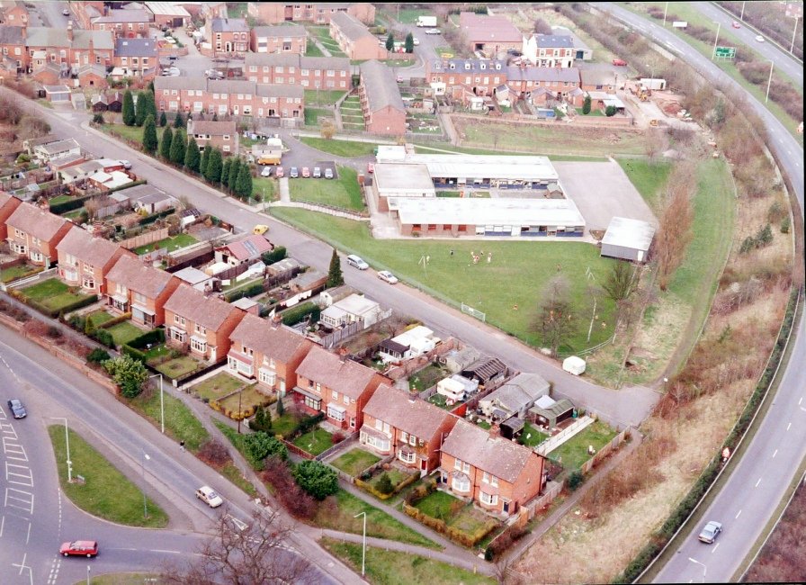
Greenlands
Studley Road
Warwick Highway with slip roads onto the Studley Road.

RLHS-DAR-125-002.JPG
Headless Cross
Evesham Road
Highfeld House on Coldfield Drive in middle right.

RLHS-DAR-125-004.JPG
Lakeside Industrial Estate
Coventry Highway
Roundabout at the end of the Alvechurch Highway at the junction with the Coventry Highway.

RLHS-DAR-125-005.JPG
Webheath
Birchfield Road
Blackpiece Lane leading up to Middle Piece Lane in middle left,

RLHS-DAR-125-010.JPG
Greenlands
Warwick Highway
Former Sandfords, later Texas Homecare, and Megabowl on Greenlands Drive.

RLHS-DAR-125-012.JPG
Greenlands
Studley Road
Woodfield Academy

RLHS-DAR-125-013.JPG
Church Hill/Lakeside Industrial Estate
Coventry Highway
The edge of Church Hill on the bottom and Lakeside on the top left.

RLHS-DAR-125-014.JPG
Woodrow
Woodrow Drive
Leys High School. now Tudor Grange in the foreground.

RLHS-DAR-125-018.JPG
Woodrow
Woodrow Drive
Leys High School. now Tudor Grange in the foreground.

RLHS-DAR-125-019.JPG
Greenlands
Oakenshaw Road
Former and Megabowl on Greenlands Drive in top right.

RLHS-DAR-125-020.JPG
Webheath
Birchfield Road
Bromsgrove Highway and the Headless Cross junction.

RLHS-DAR-125-022.JPG
Webheath
Birchfield Road
Bromsgrove Road emerging from the left by the allotments.

RLHS-DAR-125-023.JPG
Headless Cross
Evesham Road
Evesham Road from bottom left to top right. Coldfield Drive crossing the Bromsgrove Highway by Highfield House bottom right.

RLHS-DAR-125-024.JPG
Studley
Birmingham Road
The original Co-op building in the centre by Priory Square.

RLHS-DAR-125-025.JPG
Bordesley
Birmingham Road/Dagnell End Road
Meadow Farm

RLHS-DAR-125-028.JPG
St Georges
Stevenson Avenue
St. Georges First School with the Alvechurch Highway running to the right.
RLHS-DAR-125-029.JPG
Riverside
Easemore Road
St Stephen's First School

RLHS-DAR-125-030.JPG
Greenlands
Greenlands Drive
Alvechurch Highway in bottom with the former Sandfords DIY store.

RLHS-DAR-125-032.JPG
Greenlands
Studley Road
Warwick Highway going over Studley Road with slip roads back and from Studley Road.

RLHS-DAR-125-033.JPG
Woodrow
Woodrow North
Demolished in the late 90s

RLHS-DAR-125-034.JPG
Moons Moat
Coventry Highway
AT&T, formerly Istel, Communications Centre on Right.

RLHS-DAR-125-035.JPG
Winyates
Warwick HIghway
Site when Morrisons is now.

RLHS-DAR-125-036.JPG
Ipsley
Ipsley Church Lane
GKN HQ.

RLHS-DAR-125-037.JPG
Washford
Claybrook Drive
Washford Mills on left.

RLHS-DAR-125-038.JPG
Ipsley
Ipsley Church Lane.
GKN HQ.

RLHS-DAR-125-039.JPG
Moons Moat
Coventry Highway
Garage & Hotel complex in centre.

RLHS-DAR-125-040.JPG
Washford
Ickneil Street Drive
Washford Mills on the left.

RLHS-DAR-125-041.JPG
Washford
Ickneil Street Drive
Washford Mills on the left.

RLHS-DAR-125-043.JPG
Washford
Ickneil Street Drive
Washford Mill

RLHS-DAR-125-044.JPG
Woodrow
Woodrow Drive
Alexandra Hospital in foreground with the Leys High School, now Tudor Grange, in the centre.

RLHS-DAR-125-045.JPG
Ipsley
Ipsley Church Lane
GKN HQ.

RLHS-DAR-125-046.JPG
Lakeside
Alvechurch Highway
You can just see the town centre in the distance.

RLHS-DAR-125-047.JPG
Feckenham
Swansbrook Lane
Feckenham First School

RLHS-DAR-125-048.JPG
Lodge Park
Alvechurch Highway
Lodge Pool on the left.

RLHS-DAR-125-049.JPG
Feckenham
High Street
St. John the Baptist Church

RLHS-DAR-125-050.JPG
Webheath
Birchfield Road
Bromsgrove Road running parallel to Birchfield Road.

RLHS-DAR-125-051.JPG
St Georges
Alvechurch Highway
Alvechurch Highway meeting the Coventry Highway with St Georges to the West and Lakeside to the East.

RLHS-DAR-125-053.JPG
St. Georges
Coventry Highway
Alvechurch Highway meeting the Coventry Highway with St Georges to the West and Lakeside to the East.

RLHS-DAR-125-054.JPG
St. Georges
Alvechurch Highway
Alvechurch Highway meeting the Coventry Highway with St Georges to the West and Lakeside to the East.

RLHS-DAR-125-055.JPG
Alvechurch
Swan Street
An aerial view of the town

RLHS-DAR-125-056.JPG
Webheath
Heathfield Road
Heathfield Road running across the top with Pitcher Oak woods in the background.

RLHS-DAR-125-058.JPG
Greenlands
Wirehill Drive
Lodge Pool

RLHS-DAR-125-060.JPG
Woodrow
Woodrow North
Dingleside School.

RLHS-DAR-125-061.JPG
Winyates Green
Far Moon Lane
The communications tower at AT&Tat the top of the photo is a landmark

RLHS-DAR-125-062.JPG
Batchley
Foxlidyate Crescent
The "Top Shops" in Batchley

RLHS-DAR-125-063.JPG
Lodge Park
Wirehill Drive
Warwick Highway on right with slip roads off to Studley Road.

RLHS-DAR-125-064.JPG
Bordesley
Weights Lane
A green area rapidly being built on in 2017

RLHS-DAR-125-065.JPG
Bordesley
Weights Lane
Green land between the railway line and the Birmingham Road.

RLHS-DAR-125-066.JPG
Feckenham
High Street
St John The Baptist Church

RLHS-DAR-125-067.JPG
Church Hill South
Coventry Highway
Arrow Valley lake in the top left and Moons Moat in the bottom left.

RLHS-DAR-125-068.JPG
Webheath
Birchfield Road
Birchfield Road running across the top with Heathefield Road running up from the bottom right.

RLHS-DAR-125-071.JPG
Greenlands
Studley Road
Woodfield Academy opposite the slip roads off the Warwick Highway.
RLHS-DAR-125-073.JPG
Woodrow
Woodrow Drive
The former Leys High School and Leisure Centre on the bottom with the Alexandra Hospital top left.

RLHS-DAR-125-075.JPG
Park Farm
Studley Road
The bottom half of this photo shows the Park Farm South Industrial Estate. Washford Drive runs from the roundabout on the left past the garage and car showrooms.

RLHS-DAR-125-076.JPG
Woodrow South
Studley Road
Woodrow Centre is just off camera on the bottom left so the Studley Road runs diagonally up from left to right. In the centre is the St. Thomas Moore Catholic First School.

RLHS-DAR-125-077.JPG
Greenlands
Alvechurch Highway
Greenlands Drive on the left leads past the former Sandfords DIY store and the Megabowl.

RLHS-DAR-125-078.JPG
Riverside
Easemore Road
St Stephen's First School. The houses at the bottom are on Easemore Road.

RLHS-DAR-125-079.JPG
Southcrest
Plymouth Road
The dominant road is the Bromsgrove Highway with Plymouth Road running alongside past the allotments to Evesham Road/Mount Pleasant Road junction.

RLHS-DAR-125-080.JPG
Lodge Park
Wirehill Drive
Oak Hill First School in the centre with Woodfield Academy just showing on the right.

RLHS-DAR-125-081.JPG
Bordealey
Dagnell End Road
Abbey Hotel and golf course on the right.

RLHS-DAR-125-082.JPG
Feckenham
Swanbrook Lane
Feckenham First School in the foreground to the left of the pylon with the High Street and St John The Baptist Church top left.

RLHS-DAR-125-083.JPG
Woodrow
Woodrow Drive
Looking across the former Leys High School towards Park Farm Industrial Estate.

RLHS-DAR-125-084.JPG
Lodge Park
Studley Road
Woodfield Academy

RLHS-DAR-125-085.JPG
Woodrow
Grafton Close
Woodrow First School

RLHS-DAR-125-087.JPG
Woodrow
Grafton Close
Woodrow First School

RLHS-DAR-125-088.JPG
Woodrow
Churchill North
Former Dingleside Middle School.

RLHS-DAR-125-089.JPG
Woodrow
Woodrow North
Former Dingleside Middle School.

RLHS-DAR-125-090.JPG
Woodrow
Woodrow North
Former Dingleside Middle School.

RLHS-DAR-125-091.JPG
Lodge Park
Studley Road
Woodfield Academy with the slip roads off the Warwick Highway.

RLHS-DAR-125-093.JPG
Alvechurch
Swan Street
A old town surrounded by green land

RLHS-DAR-125-094.JPG
Lodge Park
Wirehill Drive
Oak Hill First School with Lodge Pool in the top left.

RLHS-DAR-125-095.JPG
Woodrow
Woodrow Drive
Looking over the rear of the Leys High School towards Woodrow South.

RLHS-DAR-125-096.JPG
Woodrow
Woodrow South
Looking across Woodrow First School towards the distinctive houses in Gradfton Close.

RLHS-DAR-125-097.JPG
Ipsley
Old Forge Drive
Ipsley Pool adjacent to the river Arrow.

RLHS-DAR-125-098.JPG
Lodge Park
Studley Road
Woodfield Academy.

RLHS-DAR-125-099.JPG
Woodrow
Woodrow South
Looking across Woodrow First School to Oakenshaw South (Lineholt Close) in the distance.

RLHS-DAR-125-100.JPG
Woodrow
Woodrow Drive
The West side of Woodrow looking across to Oakenshaw South.

RLHS-DAR-125-101.JPG
Headless Cross
Bromsgrove Highway
Musketts bridge just in front of the Headless Cross exit looking towards Redditch.

RLHS-DAR-125-102.JPG
Oakenshaw/Southcrest
Coldfield Drive
Coldfield Drive snakes up to meet the Alvechurch Highway at the B&Q roundabout.

RLHS-DAR-125-103.JPG
Southcrest
Pool Bank
Pool Bank rises from near the old Batteries site to the Southcrest Hotel. The Town Centre can be clearly seen in the distance.

RLHS-DAR-125-104.JPG
Alvechurch
Swan Street
The main road through Alvechurch meeting at The Square.

RLHS-DAR-125-106.JPG
Enfield
Windsor Road
Looking from Lowans Hill across the HDA

RLHS-DAR-125-107.JPG
Ipsley
Forge Mill Drive
The pool by Ipsley

RLHS-DAR-125-108.JPG
Webheath
Heathfield Road
An ever popular part of the town.

RLHS-DAR-125-109.JPG
Southcrest
Mount Pleasant
Looking down over Mayfields and the Batteries Site.

RLHS-DAR-125-111.JPG
Southcrest
Coldfield Drive
Alvechurch Highway. B&Q has been built but it appears that some of the buildings on the Batteries site are still standing.

RLHS-DAR-125-112.JPG
Smallwood
Millsboro Road
Former Terry's factory buildings stills present or area now known as Trafford Park.

RLHS-DAR-125-114.JPG
Enfield
Windsor Road
Modern industrial units on site of former Royal Enfield fact. Roof of HDA across the bottom of the photo. Rough land to the left the site of the former gas works.

RLHS-DAR-125-115.JPG
Feckenham
High Street
Church of St John The Baptist at the bottom.

RLHS-DAR-125-116.JPG
Bordesley
Dagnell End Road
Meadow Farm restaurant.

RLHS-DAR-125-117.JPG
Bordesley
Birmingham Road
Bordesley Garage and in bottom left the entrance to Meadow Farm restaurant.

RLHS-DAR-125-120.JPG
Alvechurch
Red Lion Street
Swan Street/Red Lion Street meet at The Square.

RLHS-DAR-125-121.JPG
Webheath
Downsell Road
Webheath Academy Primary School in centre of photo and Our Lady of Mount Carmel Catholic First School.

RLHS-DAR-125-122.JPG
Oakenshaw/Lodge Park
Alvechurch Highway
Coldfield Drive running west of the Highway and Greendlands Drive on the East. Lodge Pool in the top right

RLHS-DAR-125-129.JPG
Lakeside
Holloway Drive
Arthur Street industrial area in the foreground, B&Q at the top left.

RLHS-DAR-125-131.JPG
Alvechurch
Swan Street/Red Lion Street
Obviously a popular area to photograph

RLHS-DAR-125-132.JPG
Alvechurch
Red Lion Street
The North of the town.

RLHS-DAR-125-133.JPG
Batchley
Bromsgrove Road
Pitcheroak Wood in Foreground

RLHS-DAR-125-134.JPG
Headless Cross
Coldfield Drive
Highfield House and Bromsgrove Highway

RLHS-DAR-125-135.JPG
Southcrest
Mount Pleasant
Pool Drive and the entrance to the Southcrest Hotel at the bottom.

RLHS-DAR-125-136.JPG
Oakenshaw
Coldfield Drive
Alvechurch Highway from bottom to top on the right hand side.

RLHS-DAR-125-137.JPG
Oakenshaw South
Woodrow North
The edge of Woodrow in the bottom left and Grangers Lane in the middle top.

RLHS-DAR-125-138.JPG
Lakeside
Holloway Lane
Arthur Street industrial area.

RLHS-DAR-125-139.JPG
Southcrest/Lodge Park
Alvechurch Highway.
B&Q on the left, Lodge Pool on the right.

RLHS-DAR-125-140.JPG
Greenlands/Lodge Park
Warwick Highway
Studley Road running across the centre of the picture.

RLHS-DAR-125-141.JPG
Foxlidyate
Bromsgrove Highway
Looking east at the Batchley/Foxlidyate junction.

RLHS-DAR-125-143.JPG
Lodge Park
Wirehill Drive
Lodge Pool and Oak Hill First School.

RLHS-DAR-125-144.JPG
Studley Road
Barlic Way
Woodfield Academy bottom left, local shops in centre and St Bede's Catholic Middle School at the top.

RLHS-DAR-125-145.JPG
Woodrow/Greenlands
Studley Road
Greenlands Business Centre on the left.

RLHS-DAR-125-146.JPG
St Georges
Alvechurch Highway/Coventry Highway
Holloway Lane on the left hand side. St Georges Church in the centre and Trinity High School, formerly the County High School.

RLHS-DAR-125-147.JPG
Lodge Park
Wirehill Drive
Oak Hill First School and Woodfield Academy

RLHS-DAR-125-148.JPG
Woodroow
Woodrow South
The distinctive houses of Grafton Close.

RLHS-DAR-125-149.JPG
Woodrow
Woodrow South
Looking across to Oakenshaw South in the distance.

RLHS-DAR-125-150.JPG
Woodrow
Woodrow South
Woodrow Middle School

RLHS-DAR-125-151.JPG
Woodrow
Woodrow Drive
Hospital entrance at the bottom.

RLHS-DAR-125-152.JPG
Church Hill
Coventry Highway
Arrow Valley Lake at the top right, Moons Moat on left hand side and the original Church Hill Centre at the bottom.

RLHS-DAR-125-153.JPG
Alvechurch
Swan Street
The South of the town

RLHS-DAR-125-154.JPG
Alvechurch
The Square
The distinctive Red Lion Building top right

RLHS-DAR-125-155.JPG
Feckenham
High Street
St John The Baptist Church

RLHS-DAR-125-157.JPG
Batchley
Batchley Road
Birchensale School on the middle right and the town centre in the distance. Hazel Road and Birchensale Road in the foreground leading to Batchley Road across the centre.

RLHS-DAR-125-160.JPG
Batchley
SaltersLane
Batchley Pool in the centre. Farm in the centre is believed to be Lowan's Hill Farm

RLHS-DAR-125-161.JPG
Webheath
Downsell Road
Downsell Road leading up to Heathfield Road which leads past Webheath Village Hall to Birchfield Road.

RLHS-DAR-125-163.JPG
Lakeside
Holloway Drive
The slip roads off the Warwick Highway leading to Holloway Drive running alongside Arrow Valley lake.

RLHS-DAR-125-165.JPG
Lakeside
Studley Road
The Arthur Street Industrial area in the foreground with the Studley Road running under the Alvechurch Highway towards the town centre.

RLHS-DAR-125-166.JPG
Bordesley
Birmingham Road
Abbey Stadium clearly visible in the middle distance with the Crematorium behind.

RLHS-DAR-125-168.JPG
Bordesley
Birmingham Road
The Abbey Stadium and Crematorium in centre frame with houses on Hither Green Lane in the foreground.

RLHS-DAR-125-169.JPG
Enfield/Bordesley
Birmingham Road
Abbey Stadium, the Crematorium, Abbey Retail Park and High Duty Alloys all visible in this view.

RLHS-DAR-125-170.JPG
Enfield
Birmingham Road
A wide panoramic view over North Redditch.

RLHS-DAR-125-171.JPG
Bordesley
Birmingham Road
Sainsbury roundabout and the Crematorium

RLHS-DAR-125-172.JPG
Bordesley
Birmingham Road
Sainsbury roundabout and the Crematorium

RLHS-DAR-125-173.JPG
Enfileld
Birmingham Road
A wide panoramic view over North Redditch showing Abbey Stadium, the Crematorium, Abbey Retail Park and High Duty Alloys.

RLHS-DAR-125-174.JPG
Abbey Retail Park
Sainsbury Roundabout
Birmingham Road leading down behind Abbey Retail Park.

RLHS-DAR-125-175.JPG
Enfield
Birmingham Road
A wide panoramic view over North Redditch.

RLHS-DAR-125-176.JPG
Abbey Retail Park
Sainsbury Roundabout
Sainsbury roundabout and the Crematorium

RLHS-DAR-125-177.JPG
Bordesley
Birmingham Road
Abbey Stadium and the Crematorium

RLHS-DAR-125-178.JPG
Bordesley
Sainsbury Roundabout
Redditch Crematorim

RLHS-DAR-125-179.JPG
Astwood Bank
The Ridgeway
The Ridgeway School

RLHS-DAR-125-180.JPG
Astwood Bank
The Ridgeway
The Ridgeway School

RLHS-DAR-125-181.JPG
Astwood Bank
The Ridgeway
The Ridgeway School

RLHS-DAR-125-182.JPG
Astwood Bank
Evesham Road
A panoramic View of Astwood Bank

RLHS-DAR-125-183.JPG
Astwood Bank
Evesham Road
A panoramic View of Astwood Bank this time showing the junction with Sambourne Lane and Ferckenham Road.

RLHS-DAR-125-184.JPG
Walkwood
Tennyson Road
Tennyson Road turns right and left up to Feckenham Road with Walkwood Middle School and Vaynor First School in the centre.

RLHS-DAR-125-185.JPG
Walkwood
Feckenham Road
Tennyson Road turns right and left up to Feckenham Road with Walkwood Middle School and Vaynor First School in the centre. Windmill Drive runs across the top.

RLHS-DAR-125-186.JPG
Walkwood
Feckenham Road
Tennyson Road turns right and left up to Feckenham Road with Walkwood Middle School and Vaynor First School in the centre. Windmill Drive runs across the top.

RLHS-DAR-125-187.JPG
Walkwood
Tennyson Road
Tennyson Road turns right and left up to Feckenham Road with Walkwood Middle School and Vaynor First School in the centre. Windmill Drive runs across the top.

RLHS-DAR-125-188.JPG
Walkwood
Wordsworth Avenue
Walkwood Middle School and Vaynor First School in the top . Windmill Drive runs across the top and Wordswoth Avenue is the broad road bottom left.

RLHS-DAR-125-189.JPG
Walkwood
Wordsworth Avenue
Walkwood Middle School and Vaynor First School in the top . Windmill Drive runs across the top and Wordswoth Avenue is the broad road bottom left.

RLHS-DAR-125-190.JPG
Walkwood
Harrison Road
Harrison Road runs vertically up from The Meadway to Tennyson Road.

RLHS-DAR-125-191.JPG
Webheath
Feckenham Road
Walkwood Middle School and Vaynor First School

RLHS-DAR-125-192.JPG
Walkwood
Feckingham Road
Walkwood Middle School and Vaynor First School and the mainly pre-new town housing of Walkwood.

RLHS-DAR-125-193.JPG
Walkwood
Feckenham Road
Walkwood Middle School and Vaynor First School.

RLHS-DAR-125-194.JPG
Walkwood
Feckenham Road
Vaynor First School

RLHS-DAR-125-195.JPG
Oakenshaw
Alvechurch Highway
The Clover Leaf, an early picture with very little trees and shrubbery visible. Sandfords DIY store and the Megabowl in the background

RLHS-DAR-125-196.JPG
Oakenshaw
Alvechurch Highway
The Clover Leaf, an early picture with very liitle trees and shrubbery visible. Sandfords DIY store in the background.

RLHS-DAR-125-197.JPG
Lakeside
Warwick Highway
Partial Cloverleaf Junction onto Holloway Drive.

RLHS-DAR-125-198.JPG
Greenlands
Greenlands Drive
The Clover Leaf,on the Alvechurch Highway with Sandfords DIY store and the Megabowl in the background on the left.

RLHS-DAR-125-199.JPG
Oakenshaw
Alvechurch Highway
Tescos Superstore where Oakenshaw Farm once stood.

RLHS-DAR-125-200.JPG
Church Hill
Church Hill Way
Church Hill Way, a buses only road, passes Abbeywood First School and Church Hill Middle School.

RLHS-DAR-125-201.JPG
Church Hill
Coventry Highway
Arrow Valey Lake in the bacground and Moons Moat Ancient Monument in the foreground.

RLHS-DAR-125-202.JPG
Webheath
Birchfield Road
At the top end of the green space lies Webheath Village Hall.

RLHS-DAR-125-205.JPG
Church Hill
Maisemore Close
Abbeywood First School and Church Hill Middle School with its large green playing field.

RLHS-DAR-125-206.JPG
Feckenham
Droitwich Road/Alcester Road
Droitwich Road/Alcester Road/High Street junction.

RLHS-DAR-125-207.JPG
Feckenham
High Street
St John The Baptist Church

RLHS-DAR-125-208.JPG
Feckenham
High Street
St John The Baptist Church

RLHS-DAR-125-209.JPG
Feckenham
Swanbrook Lane
Feckenham First School

RLHS-DAR-125-211.JPG
Feckenham
High Street
High Street junction where the Droitwich Road changes to the Alcester Road.

RLHS-DAR-125-212.JPG
Feckenham
High Street
High Street junction where the Droitwich Road changes to the Alcester Road.

RLHS-DAR-125-213.JPG
Feckenham
High Street
High Street junction where the Droitwich Road changes to the Alcester Road.

RLHS-DAR-125-214.JPG
Feckenham
High Street
High Street junction where the Droitwich Road changes to the Alcester Road.

RLHS-DAR-125-215.JPG
Walkwood
Feckenham Road
Windmill Drive on the far left run parallel with Feckenham Road which passes Walkwood Middle School and Vaynor First School.

RLHS-DAR-125-216.JPG
Southcrest
Plymouth Road
St Luke’s First School at the junction of Plymouth Road, Evesham Road and Mount Pleasant. The Park Inn is opposite the junction.

RLHS-DAR-125-218.JPG
Southcrest
Evesham Road
St Luke’s First School at the junction of Plymouth Road, Evesham Road and Mount Pleasant. The Park Inn is opposite the junction.

RLHS-DAR-125-219.JPG
Southcrest
Plymouth Road
St Luke’s First School at the junction of Plymouth Road, Evesham Road and Mount Pleasant. The Park Inn is opposite the junction.

RLHS-DAR-125-220.JPG
Southcrest
Plymouth Road
POlymouth Road turns up parallel to the Bromsgrove Highway, past the Alotments and \st \lukes school to join Evesham Road/Mount Pleasant.

RLHS-DAR-125-221.JPG
Walkwood
Windmill Drive
The Bramley Cottage on the middle left where Callow Hill Lane joins Windmill Drive.

RLHS-DAR-125-222.JPG
Walkwood
Windmill Drive
The Bramley Cottage on the middle left where Callow Hill Lane joins Windmill Drive.

RLHS-DAR-125-223.JPG
Church Hill
Church Hill Way
The bus route, Church Hill Way, passes top right to middle bottom past the original Church Hill Centre which has now been rebuild 0n the other side of the road.

RLHS-DAR-125-224.JPG
Crabbs Cross
Evesham Road
Harry Taylor First School is the dominant feature but many other buildings in the area as still there today.

RLHS-DAR-125-225.JPG
Crabbs Cross
Evesham Road
Harry Taylor First School is the dominant feature but many other buildings in the area as still there today, although the garage complex has now been replaced by residential housing.

RLHS-DAR-125-226.JPG
Crabbs Cross
Evesham Road
Harry Taylor First School is the centre and opposite the path that runs down to Oakenshaw.

RLHS-DAR-125-227.JPG
Crabbs Cross
Evesham Road
the Star & Garter pub, from which the roundabout gets its name, is just visible on the middle right.

RLHS-DAR-125-228.JPG
Winyates
Winyates Way
Ipsley CoE RSA Academy

RLHS-DAR-125-229.JPG
Winyates
Winyates Way
Ipsley CoE RSA Academy

RLHS-DAR-125-230.JPG
Winyates
Winyates Way
Ipsley CoE RSA Academy

RLHS-DAR-125-231.JPG
Winyates
Doblen Lane
Doblen Lane across the bottom, Warwick Highway across the top and Ipsley CoE RSA Academy in the middle.

RLHS-DAR-125-232.JPG
Winyates
Winyates Way
Ipsley CoE RSA Academy in the middle.

RLHS-DAR-125-233.JPG
Winyates
Winyates Way
Warwick Highway across the top and Ipsley CoE RSA Academy in the middle.

RLHS-DAR-125-235.JPG
Winyates
Warwick Highway
Warwick Highway down the left hand side and Ipsley CoE RSA Academy in the middle.

RLHS-DAR-125-236.JPG
Church Hill
Coventry Highway
Slip roads of the Coventry Highway leading to Church Hill North and Church Hill South. The Oast House pub stands out in the foreground

RLHS-DAR-125-237.JPG
Riverside
Easemre Road
St. Stephen's First School

RLHS-DAR-125-238.JPG
Ipsley
Icknield Street Drive
Golden Goose Pub in the centre of the photograph. Adjacent to the left is the original BMX track.

RLHS-DAR-125-239.JPG
Winyates
Warwick Highway
Ipsley CoE RSA Academy in the Centre

RLHS-DAR-125-241.JPG
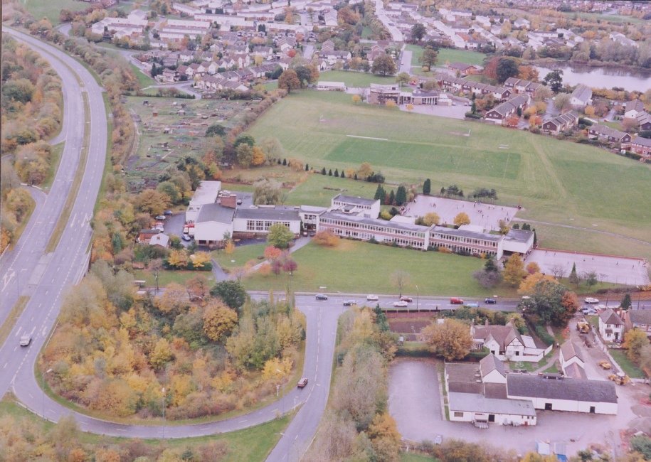
St Georges
Other Road
The County High School, now Trinity High School and Sixth Form College.

RLHS-DAR-125-242.JPG
St Georges
Coventry Highway
Looking west towards the town centre with the former County High School clearly visible.

RLHS-DAR-125-243.JPG
St Georges
Alvechurch Highway
The former County High School, now Trinity High School and Sixth Form College.

RLHS-DAR-125-244.JPG
St Georges
Coventry Highway
The former County High School, now Trinity High School and Sixth Form College.

RLHS-DAR-125-245.JPG
St Georges
Coventry Highway
The Former County High School, now Trinity High School and Sixth Form College.

RLHS-DAR-125-246.JPG
Town Centre
Coventy Highway
The roundabout at the junction with the Alvechurch Highway. Part of the Lakeside Industrial area on the left.

RLHS-DAR-125-247.JPG
St. Georges
Coventry Highway
The former County High School, now Trinity High School and Sixth Form College.

RLHS-DAR-125-248.JPG
Town Centre
Coventry Highway
The former County High School, now Trinity High School and Sixth Form College.

RLHS-DAR-125-249.JPG
Town Centre
Alvechurch Highway
The former County High School, now Trinity High School and Sixth Form College.

RLHS-DAR-125-250.JPG
St Georges
Other Road
The former County High School, now Trinity High School and Sixth Form College.

RLHS-DAR-125-251.JPG
Woodrow
Woodrow Drive
Leys High School, now Tudor Grange Academy.

RLHS-DAR-125-252.JPG